MasterWorks: Journey Through History (2018) is a new app for Oculus Rift and Gear VR that takes you on a guided tour through four cultural sites spanning three continents. Created using photogrammetry and presented with audio clips from experts, collectible artifacts and 3D 360 photos, the app does more than just let you explore the sites; it preserves these sites digitally while teaching you about the real-world threats they face amidst a rapidly changing climate.
Spanning over 3000 years of human history, you’ll be able to visit:
- The historical city of Ayutthaya, Thailand, the second capital of the Siamese Kingdom
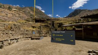
- Chavín de Huántar, a pre-Incan temple in the Peruvian Andes
- Mesa Verde Native American cliff dwellings of Colorado
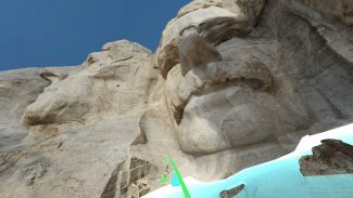
- The stone carvings of Mt Rushmore in South Dakota
You can download MasterWorks: Journey Through History for Rift here, and for Gear VR here.
Norman Chan and Jeremy Williams of Tested visited CyArk, the studio behind MasterWorks, to talk a little about how they captured the sites.
Founded in 2003, the non-profit company’s mission, CyArk CEO John Ristevski told Tested, is to capture, share and archive the world’s cultural heritage.
“We capture these places in accurate 3D, we archive it in case something happens to these sites – in case of destruction or damage – and we also makes this data available in interesting ways, such as in VR,” Ristevski explained.
The studio does this by using a laser-scanning Light Detection and Ranging device (LIDAR) and photo imagery using professional-level DSLRs and imagery captured via drones. Combining these two fundamental techniques, the company can make highly-accurate recreations of scenes like the ones seen below.

As it stands now, the process of creating these experiences is still pretty arduous, requiring between 5-7 days of on-site time to capture an area about the size of a quarter-mile squared area (about 400m squared).
CyArk Director of Product Scott Lee tells Tested their team uses motion-controlled camera rigs to capture the photos, which he says ensures the required 60-80 percent overlap is obtained to generate the photogrammetric models.
You can check out the full video interview here.
The post ‘MasterWorks’ Uses Photogrammetry to Take You on a Guided VR Tour of 4 Fully Explorable Heritage Sites appeared first on Road to VR.
Ream more: https://www.roadtovr.com/masterworks-uses-photogrammetry-take-guided-vr-tour-4-fully-explorable-heritage-sites/


No comments:
Post a Comment